All Maps are Not Created Equally
Cartography is an amazing field, and maps can encompass art, science, fiction and beyond. To get a sense of the range of what a “map” may contain, check out this amazing array of maps in this Cool Cartography article!
Good maps make a difference!
Tell A Story
While there many ways to make a map, ultimately there should only be one story to tell. A map should cut through confusion and clarify where things are in space (or time). If a map is effective, a reader shouldn’t need lots of time to interpret the information the map is trying to portray.
Maps can be very effective and beautiful! They do not need to be one or the other. Good visualizations often simplify to the pieces (landscapes, points of interest, temporal change) of interest, and remove any other distractions.
Keep Things Simple!
Maps don’t need to have every single layer or detail. They need the relevant details, so anyone can quickly take a look at the map, orient themselves, and extract the important information.
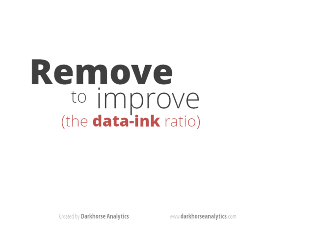
This animation (created by Darkhorse Analytics, and used in Jenny Bryan’s excellent stat545 course) shows how simplification can make a big difference in communication. Granted, this is for figures, and not specifically for maps, but the point is the same.
Projections and Coordinate Reference Systems (CRS)
This is often one of the hardest and most complicated parts about working with spatial data. This is a (very simplified) summary of the difference between projected (PCS) and geographic coordinate systems (GCS). A few helpful websites to check/identify Proj4 strings or EPSG codes:
One way to think about projections is they represent different types of tableclothes that get stretched over a 3-dimensional globe. If you are working with locations on the tablecloth, the accuracy of your measurements will be higher than if you are near the edges or off the tablecloth and somewhere else on the globe.
GCS (Geographic Coordinate System)
GCS are based on spherical earth models (3-dimensional), and therefore use spherical coordinate systems (e.g., latitude and longitude), or datum, in a 3-dimensional space to define locations based on a spheroid/ellipsoid model (of which there are many). The datum is used to link the spheroid model to the earth’s surface. Calculating distances along this model utilizes geodesic or Great Circles. A few common GCS:
- NAD83 [4269]:
ellipsoid= GRS 1980,datum= North American Datum 1983,unit= Degree,prime meridian=Greenwich) - NAD27 [4267]:
ellipsoid= Clarke 1866,datum= North American Datum 1927,unit= Degree,prime meridian=Greenwich)
PCS (Projected Coordinate Systems)
PCS project locations onto a 2-dimensional Cartesian coordinate plane. That’s why we refer to these as map projections, because they help flatten the 3d spheroid onto a flat plane, which is good for displaying maps. Different projections have different ways of stretching the 3-d earth’s surface onto a flat 2-d plane. By putting things onto a flat 2-d surface, calculations and analysis can be calculated on a grid, versus with geodesic (Great Circles). It’s possible to do great circle calculations with a PCS, these are sometimes referred to as geodetic calculations. So, these are basically GCS projected onto a flat surface…so they have the GCS components, plus a “projection” component. Some common PCS:
- WGS84 [4326]:
ellipsoid= WGS 1984,datum= World Geodetic System 1984,unit= Degree,prime meridian=Greenwich) - NAD83/Albers [EPSG: 3310]:
geodetic CRS= NAD83(NSRS2007),ellipsoid= GRS 1980,datum= North American Datum 1983 (National Spatial Reference System 2007),unit= meter,prime meridian=Greenwich) - NAD83(NSRS2007/UTM Zone 10N) [EPSG: 3717]:
geodetic CRS= NAD83,ellipsoid= GRS 1980,datum= North American Datum 1983,unit= meter,prime meridian=Greenwich) - NAD83(2011)/Conus Albers [EPSG: 6350]:
geodetic CRS= NAD83(2011),ellipsoid= GRS 1980,datum= North American Datum 1983,unit= meter,prime meridian=Greenwich) - NAD83/California Zone 4 (ftUS) [EPSG: 2228]:
geodetic CRS= NAD83,ellipsoid= GRS 1980,datum= North American Datum 1983,unit= US survey foot,prime meridian=Greenwich)
Overwhelmed? It’s okay…one step at a time!
Overwhelmed!?